Typically, Summer 2018’s heatwave broke down soon after the schools broke up. Yes, we needed the rain and, yes, plenty of people were sick of the heat. But teachers, young families and anyone holidaying at home this August may feel short-changed.
It is easy to forget, now the puddles have returned, just how remarkable the first half of summer was. In fact, although meteorologists define summer as the three months from June to August, it feels like this year’s summer started halfway through spring.
In just a few weeks, we exchanged chilly easterlies with sunny southerlies. Following a delayed start to spring, all of nature blossomed at once during the second half of the season. This was bad news for hay fever sufferers: the explosive flowering of trees and grasses led to the highest pollen counts for more than a decade.
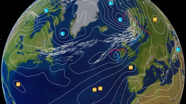
A large area of high pressure stretched from Scandinavia to the Azores and refused to budge. This became a blocking anticyclone diverting the jet stream far to the north of Britain. Rainclouds were delivered to Iceland whilst much of northern Europe remained cloud-free.
During June and July, thermometers topped 30 Celsius in Scotland, Lapland and even the Arctic Circle. This heat hadn’t wafted in from warmer climes; this was home-grown heat, the result of weeks of baking sunshine.
By the midpoint of Summer 2018, a comparison of satellite images between May and July highlighted how much the ground had been baked. Those earlier flowering grasses were now brown fields up and down the country. A stark side effect of the driest first half of summer since comparable records began in 1961.
How quickly it can change. The end of July brought the first significant rain of the summer for many. Although August began with a few hot days, much more mixed weather has now returned to all parts of the country.
Northern Europe’s anticyclone has been unblocked by a recharged jet stream, itself fuelled by an increased temperature gradient across the North Atlantic. Low pressure, cloud, rain and cool winds have returned to our shores following their long sabbatical. British summer as we know it is back. It was almost as good as ’76, some might say, but it was disappointing in the end.

Indeed, recent gloomy skies mean we would need a particularly dazzling end to August for this year’s summer to beat 1976’s as the sunniest on record. Recent wet weather has already pushed Summer 2018 out of the top five driest summers in UK records that extend back to 1910.
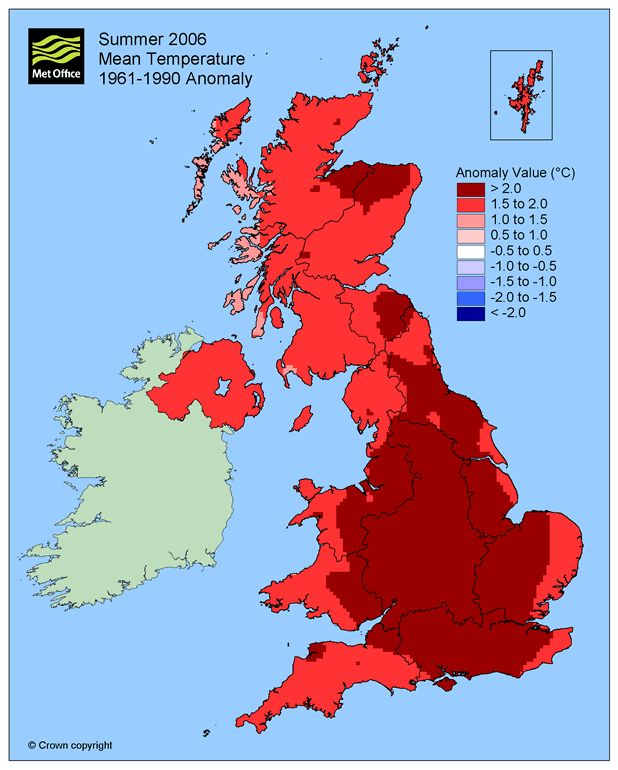
1976 may remain the gold-standard for British summers but, for mean temperature, it wasn’t the warmest on record. Mean temperature is when day time highs and night time lows are combined and Summer 1976 comes third in the league table. The second warmest summer on record is 2003, when the UK’s all-time highest temperature of 38.5 C was recorded in Faversham, Kent. 2006 is the UK’s warmest summer since records began in 1910, following a hot July.

Where Summer 2018 is placed in the record books will come down to very fine margins. Just one hundredth of a degree Celsius separates the third placed summer with the first. It’s now mid-August and a comparison of running totals suggests there is very little to separate 2006’s summer with this year’s.
We can say that Summer 2018 is very likely to end up in the top five warmest summers on record. However, given how close the top three summers are, 2018 could just as easily be the fourth warmest as the first.
Even slightly above average temperatures during the next couple of weeks would seal 2018’s place in history. But remember, we need to consider both day and night temperatures. Whilst day time temperatures during the rest of August are unlikely to stray far from average, the muggy nights of this weekend could be replaced by some chilly nights by the end of the month. Autumn is almost here, but what a summer it has been.