
It’s a testament to how often British Bank Holidays disappoint that, in the forty years since it was introduced, temperatures had never exceeded 23.6ºc on the early May Bank Holiday Monday.
At least, not until this year.
This year, the usual Bank Holiday washout script was torn up and re-written. Rainclouds were replaced with sunshine. Records were broken. When 28.7ºc was reached in Northolt, West London, the previous top temperature was beaten by more than five degrees.
For any Bank Holiday beach-goers, roasting in the afternoon sunshine, it may have been hard to believe that just two months earlier large parts of the country were blanketed in deep snow.
Hard to believe, that is, until they took a dip in the toe-numbing waters. At just 12ºc around southwest coasts and 8ºc close to the northeast, the seas were still recovering from March’s Siberian winds.
Beast from the East part one, at the beginning of the month, brought sustained and brutal cold to every part of the UK from the Isles of Scilly to Shetland. Tredegar in Wales recorded a maximum temperature on the 1 March of just -4.7ºc, making it the coldest spring day in records that stretch back to 1910. Add into the mix a raw easterly wind and many places felt a chill akin to the minus double digits.
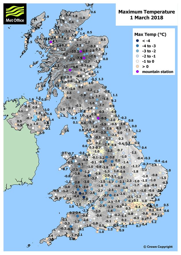
Two rare Met Office red warnings were issued for disruptive snowfall in parts of Scotland as well as Wales and the South West between 28 February and 1 March. The snow stranded 1,000 vehicles overnight on the M80 and drivers were also stuck on roads such as the A30 and A38 in Devon.
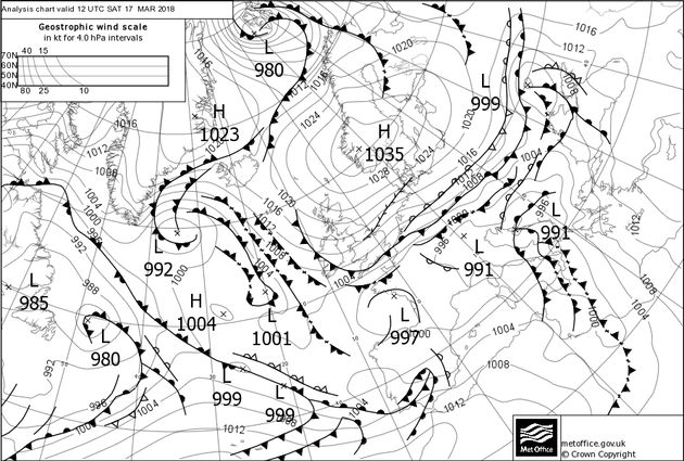
Beast from the East part two swept across the country in mid-March and brought a return to sub-zero temperatures, icy winds and further disruptive snowfall in places.
Little wonder the seas remain so chilly in May. The air temperature may have switched from record-breaking cold to record-breaking heat in just two months but the sea has warmed sluggishly.
Water is a relatively slow conductor of heat. This means that, combined with the continuous moving and mixing of water molecules, it takes much longer for the sea to warm in spring and summer compared to the land. However, water also stays warm for longer – leading to a delay in cooling during autumn and winter.
These lag effects in warming and cooling can lead to a sea temperature frequently at odds with the surrounding air temperature from season to season. It’s also why the UK, a small island nation surrounded by seas, doesn’t often experience extremes of temperature.
The largest expanse of water near our shores lies to the west in the form of the Atlantic Ocean and that’s where our weather comes from much of the time. The jet stream, a ribbon of fast-flowing air high in the sky, tends to act as an atmospheric conveyor belt. Low pressure systems form over the Atlantic and are carried towards the British Isles by the jet stream above, which typically flows from west to east.
When the jet stream is strong, we receive a full complement of cloud, wind and rain from the west. Atlantic weather, as well as being blustery and damp, acts as the UK’s thermostat, keeping us in mild winters and cool summers.
At times during Spring 2018, however, this moderating influence has been notably absent, resulting in some exceptional weather. A particularly dominant area of high pressure built up over Scandinavia during March. Known as a blocking anticyclone, this Scandinavian High held off the usual Atlantic westerlies and sent Siberian easterlies towards the UK. Beast from the East arrived – not once, but twice.
Fast forward to the early May Bank Holiday weekend and we encountered another blocking anticyclone lodged to the east of the British Isles. Once again, Atlantic winds en route to the UK were stopped. This time, however, Siberian winds had lost their bite. By May, winds from the continent tend to be warm and sunny.
Record-breaking cold early in spring followed by record-breaking heat later in the season; two very different outcomes but both the result of a Scandinavian High. However, whilst a blocking anticyclone can disrupt the eastward-moving jet stream, a weakened jet stream is ultimately responsible for the formation of blocking anticyclones. This ‘chicken and egg’ scenario illustrates just how complex and interconnected global weather patterns can be.
In fact, it’s during spring in particular that we are most likely to find blocking anticyclones and weakened jet streams. The jet stream is fuelled by temperature contrasts across the Northern Hemisphere and during spring these contrasts decline as continents warm but oceans remain cool.
For that reason, it’s not unusual at this time of year to find slow, meandering jet streams, blocking anticyclones, and continental-style swings in temperature in the UK.
The causes of Spring 2018’s particularly pronounced cold and hot spells are complex and varied. March’s Siberian easterlies were a response to a dramatic wind reversal 80 thousand feet above the North Pole in the Stratosphere. This itself can be traced back to lively thunderstorms in the tropical West Pacific during January, which produced energetic reverberations high in the atmosphere throughout the Northern Hemisphere.
This year’s record-breaking Bank Holiday is more likely to be a quirk of fate. After all, particularly warm temperatures during early May are not unheard of, they’ve just never coincided before with the early May Bank Holiday Monday. It’s only taken 40 years for our fortunes to change.